The tradition & historical record
6 min read · 2 sourcesSheldon tapestries This classification of tapestries followed the exhibition at the Victoria and Albert Museum, London, in 1914 of the tapestry maps, commissioned by and for the Sheldon family of Beoley and Weston, which had given rise to the question of whether there might be other products from workshops at Barcheston for which there was only a presumption of existence. One hundred and twenty-one woven tapestries were first identified in the 1920s as products of that weaving venture planned by William Sheldon, outlined in his recently catalogued will, its details previously unknown. Most are small furnishing items, such as cushion covers produced in sets of six depicting a Biblical story. Examples are to be seen in three major collections: the Victoria and Albert Museum, London; the Metropolitan Museum of Art, New York; and the Burrell Collection, Glasgow, Scotland. The first attributions, then dated to the later 16th century, were made by a Worcestershire antiquary, John Humphreys, without clear criteria but in the belief that William Sheldon’s proposed venture must have been successful. A few years later further examples were so classified on a typological basis, its base point insecure. No documentary evidence was then, or is now, associated with any tapestry, so no definitive origin for any piece can be established. 1
The Sheldon Tapestry Maps
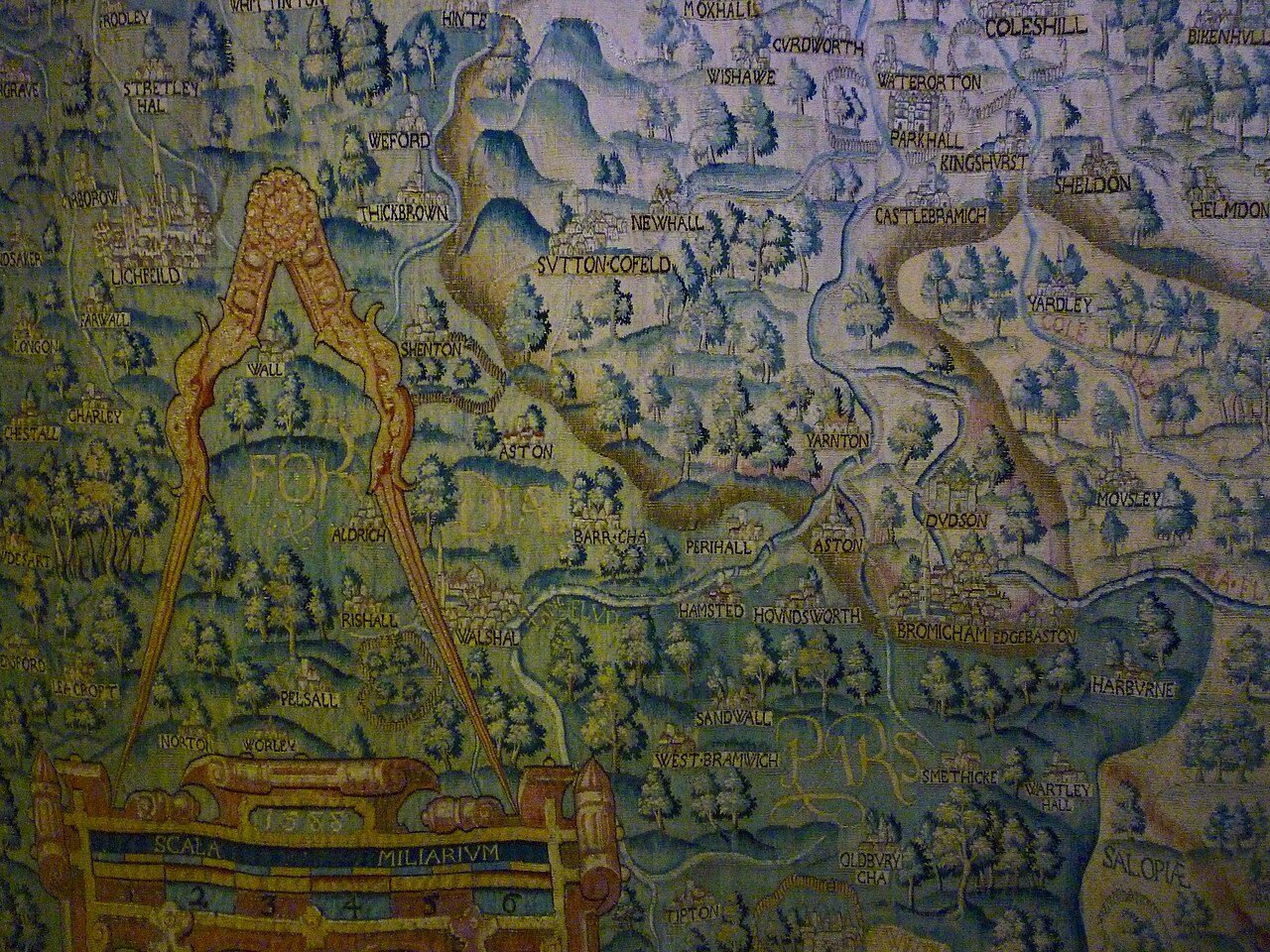
The four tapestry-woven maps, commissioned in the late 1580s by Ralph Sheldon (1537–1613), were based on the county surveys of Christopher Saxton. The tapestries focused on the counties of Gloucestershire, Worcestershire, Warwickshire and Oxfordshire. Though each centred on one county, each also depicted as many of those adjacent as needed to create a rectangle of the dimensions required. Designed to hang together in Ralph Sheldon's house in Weston, in Long Compton, Warwickshire, they would have presented a view across central England, from the Bristol Channel to London, covering the counties where Sheldon’s family and friends held land. The maps are important in making a picture showing the landscape of central England in the 16th century, at a time when modern map making was in early development. Of the original four tapestries, three survive in part and only the Warwickshire one is still complete, now displayed at Market Hall Museum, Warwick. 1
Background
In 1570 Ralph Sheldon's father, William, outlined plans which would, if successful, set up a weaving enterprise in his manor house at Barcheston, Warwickshire. Richard Hyckes, his background uncertain, was allowed use of the property rent-free but for a limited term on condition that he organised the weaving of tapestries and textiles suitable for clothing. To attract workers interest-free loans were offered to any who would work, or perhaps train, alongside Hyckes. Similar arrangements are now known to be paralleled elsewhere, their documents unavailable to the 1920s researchers At the same time Hyckes was working, with the title of arras-maker, in the Great Wardrobe in London, part of the household departments of Queen Elizabeth I. He was head of the team responsible for the care and repair of the 2,500 tapestries inherited from her father King Henry VIII. He therefore had contacts amongst experienced emigre weavers now resident in London but trained in the Low Countries, the heart of the tapestry weaving industry. Ralph Sheldon allowed the venture to continue following his father's death; he subsequently commissioned the tapestry maps, but nothing substantiates the confident assertion, frequently voiced, that they were woven at Barcheston or even in Warwickshire. Over a period of thirty years only twelve weavers have been identified as having an indirect association with the area but not specifically with the venture; even supposing double that number it seems unlikely that there was sufficient skilled labour to organise a project on the scale of the map project available in Barcheston at that time. Supply of sufficient materials could also have been problematic. 1
Design
Each of the four tapestry maps measured approximately 20 feet (6.1 m) wide and 13 feet (4.0 m) high and was based on the recent county maps made by Christopher Saxton, which provided information on rivers, towns, and geographical features such as woods and forests. Each tapestry focussed on a single county and the area of tapestry around that county boundary was filled in with topographical details taken from the appropriate adjoining Saxton county maps. To enable the central county to stand out on each tapestry, it was given a pale background and a red border, while the backgrounds of neighbouring counties were woven in contrasting shades. Because it bordered so many other counties, the Oxfordshire tapestry, for instance, included but with fewer details areas from nine of Saxton's maps; Warwickshire drew on seven others. The tapestry designer had to greatly enlarge the scale since the single counties on the Saxton printed maps measured approximately 12 by 10 inches (30 by 25 cm). The tapestries therefore had space to add more detail than Saxton’s maps, so they include more natural and man-made features in each area, vary the species and style of trees and size of hills and illustrate landmarks such as fire beacons and windmills. Most villages were drawn in a similar style, as houses grouped around a central church, though towns are more varied and shown in more detail so may have been based on more accurate drawings. Coventry was depicted with many church spires surrounded by its defensive walls, and Worcester included the stone-arched bridge over the River Severn. 1
Dispersal
The tapestries remained in the house and in 1738 George Vertue recorded that he had seen the Elizabethan maps and later copies of Oxfordshire and Worcestershire hanging together in the Great Drawing Room in Weston. Thirty years later in 1768 Walpole saw only ‘Three large maps of Counties in tapestry’. In 1781 when the contents of the house were sold, only three pieces were named and listed by size, in the entries in Christie's auction catalogue. The three tapestries listed are identifiable as the 16th-century Warwickshire map with its 17th-century border and the two 17th-century copies of Oxfordshire and Worcestershire; they were bought by Horace Walpole. He later gave them to Lord Harcourt, who left them to the Archbishop of York and in 1827 they were given to the Yorkshire Philosophical Society who put them on display. In 1897 the Warwickshire tapestry was lent to the new Birmingham museum at its opening, and in 1914 the tapestries were exhibited at the Victoria and Albert Museum in London. Because the border around the Warwickshire map had been replaced in the 17th century, it had been assumed that the whole map had also been made at that time. 1
Current locations
The history of the three 16th-century maps is more complicated. 1
The text above is adapted from the Wikipedia article “Sheldon tapestries”, available under the Creative Commons Attribution-ShareAlike 4.0 licence. 1
Sheldon tapestries is tapestries attributed to the English workshops established by William Sheldon in the 1560s, according to the structured record cited below. This entry was generated automatically from that record and has not yet been reviewed by a person familiar with the tradition. 2
The source record links this tradition to 1 external register, which can be verified through the citation. 2